Israel Building New Military Dividing Line Across Gaza, Satellite Images Suggest
WORLD
Israel is constructing a new military dividing line in Gaza, separating the far north of the strip.
Troops are in control of and clearing an area across the width of northern Gaza.
Satellite images also show Israeli troops and vehicles stationed along the new divide.
Reports suggest the images indicate that Gaza is being divided into zones to make it easier to control.
An IDF spokesperson told the BBC that they are "targeting terrorist operatives and infrastructure" in northern Gaza.
Dr. H.A. Hellyer, a Middle East security expert, stated that Israel is preparing to block Palestinian civilians from returning to the northern Gaza governorate.
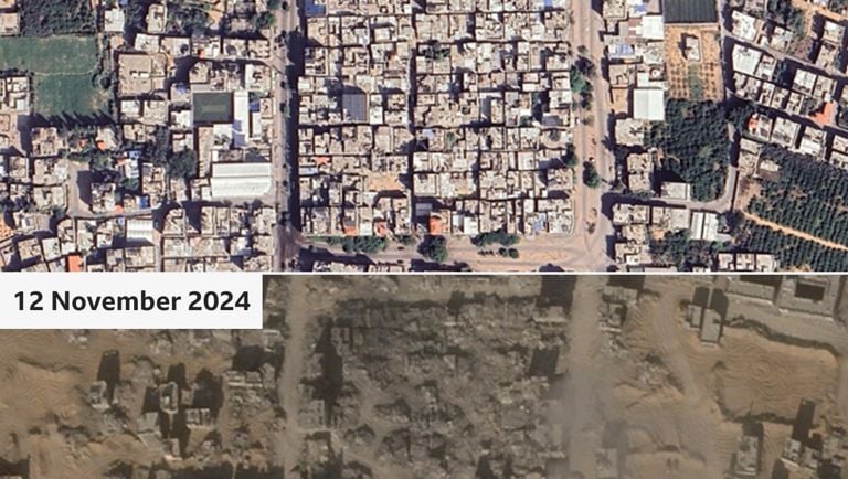
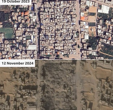
Satellite images reveal two road sections linked by cleared land, with buildings being demolished between them.
Over 100,000 people have been displaced from northern Gaza.
The IDF has denied harming civilian infrastructure, arguing that their actions are aimed at removing bias from Hamas.
The new corridor area resembles previous military corridors in Gaza, with newly constructed roads connected by military positions emerging at regular intervals.
Dr. Eado Hecht from the Begin–Sadat Center for Strategic Studies (BESA) admits the data shows a new dividing line but questions whether it is intended to be permanent.
Concerns have been raised about the safety of Palestinian civilians in besieged towns in northern Gaza.
The UN and aid organizations have expressed alarm about the situation, with up to 60,000 people potentially still remaining in northern Gaza.
The UN also reports that no humanitarian aid has entered northern Gaza in 50 days.
Israel's Finance Minister Bezalel Smotrich has recommended that Israeli troops take full control of Gaza and encourage half of the Palestinian civilian population to leave within two years.
Source : FIJI ONE NEWS
Duavata News (Fiji) PTE LIMITED © 2024
☏ 3317438
📧 editor@duavata.news